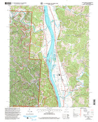
2002 Map of Apple Grove
USGS Topo · Published 2006About this map
The Ohio River serves as the dominant artery of this landscape, separating the West Virginia riverfront of Mason County from its Ohio neighbors. The river valley is punctuated by significant infrastructure like the Gallipolis Lock and Dam, which manages the water levels for a system that includes Raccoon Island and several creek mouths. On the West Virginia side, the communities of Apple Grove, Mercers Bottom, and Ashton follow the river road, supported by local institutions such as Beale School and Beale Chapel. The topography shifts abruptly from the flat floodplains to the dissected ridges of the Wayne National Forest. These hills are crisscrossed by a network of rural routes like Yellowtown Road and Mercerville Road, leading to established local landmarks like Elizabeth Chapel and Bruce Chapel. Evidence of small-scale extraction is visible in several mines tucked into the western hollows.
Find a feature on this map
64 named features on this map. Tap any name to fly to it.
Don’t see what you’re looking for? This feature index may not catch every label — zoom into the map to look around manually.
Map Details
Editions of this 2002 Apple Grove Map
This is the sole edition of this map. No revisions or reprints were ever made.
Other maps of this area

1906 · Bidwell
USGS Topo · 1:62,500

1906 · Athalia
USGS Topo · 1:62,500

1906 · Glenwood
USGS Topo · 1:62,500

1908 · Bidwell
USGS Topo · 1:62,500

1908 · Athalia
USGS Topo · 1:62,500

1908 · Glenwood
USGS Topo · 1:62,500

1908 · Point Pleasant
USGS Topo · 1:62,500

1926 · Point Pleasant
USGS Topo · 1:62,500

1929 · Point Pleasant
USGS Topo · 1:62,500

1957 · Beech Hill
USGS Topo · 1:24,000