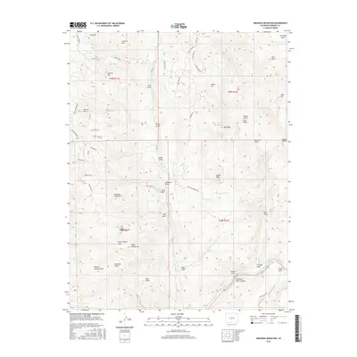
2016 Map of Arkansas Mountain
USGS Topo · Published 2016About this map
Arkansas Mountain and the high ridges of the Sangre de Cristo foothills dominate this portion of Fremont County. The terrain is characterized by a dense network of gulches and peaks, including Garell Peak, Falls Gulch Mtn, and the distinctive Cedar Springs Mtn. The southern edge of the map reveals the dramatic geography of the Arkansas River Canyon, where the Arkansas River cuts through the landscape. While largely uninhabited by major settlements, the presence of Mine Gulch and numerous roads such as Spruce Mountain Rd and Co Rd 12 suggest a history of resource extraction and mountain access. Smaller topographic details like Chauncy Hayden Gulch and Henthorn Gulch provide specific landmarks for those tracing local family names or land use patterns in this high-elevation region.
Find a feature on this map
65 named features on this map. Tap any name to fly to it.
Don’t see what you’re looking for? This feature index may not catch every label — zoom into the map to look around manually.
Map Details
Editions of this 2016 Arkansas Mountain Map
This is the sole edition of this map. No revisions or reprints were ever made.
Other maps of this area

1954 · Pueblo
USGS Topo · 1:250,000

1956 · Cameron Mountain
USGS Topo · 1:62,500

1957 · Pueblo
USGS Topo · 1:250,000

1958 · Pueblo
USGS Topo · 1:250,000

1959 · Black Mountain
USGS Topo · 1:62,500

1959 · Howard
USGS Topo · 1:62,500

1959 · Cotopaxi
USGS Topo · 1:62,500

1962 · Pueblo
USGS Topo · 1:250,000

1966 · Pueblo
USGS Topo · 1:250,000
1980 · Echo
USGS Topo · 1:24,000