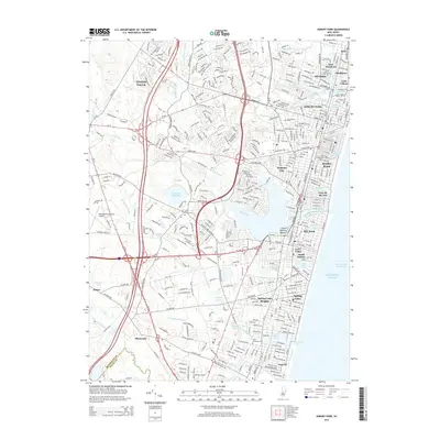
2014 Map of Asbury Park
USGS Topo · Published 2014About this map
Asbury Park and its neighboring seaside boroughs define this coastal landscape, showing a densely developed shoreline from Allenhurst south to Sea Girt. The map reveals a complex water system of coastal lakes and ponds, including the expansive Deal Lake, Sylvan Lake, and Lake Como, which separate the various beach communities. Inland, the character shifts toward the Glendola Reservoir and the Monmouth Executive Airport, illustrating the balance between residential expansion and essential infrastructure. Geographers and historians can observe how transportation corridors like RT-35 and RT-71 connect these established Jersey Shore towns. Significant local landmarks such as Saint Annes Cem and Saint Catharine Cem offer specific points of interest for genealogical research, while the presence of Allaire park in the west highlights the preserved green space amidst the suburban fabric of Tinton Falls and Allenwood.
Find a feature on this map
67 named features on this map. Tap any name to fly to it.
Don’t see what you’re looking for? This feature index may not catch every label — zoom into the map to look around manually.
Map Details
Editions of this 2014 Asbury Park Map
This is the sole edition of this map. No revisions or reprints were ever made.
Other maps of this area

1888 · Asbury Park
USGS Topo · 1:62,500

1888 · Sandy Hook
USGS Topo · 1:62,500

1893 · Sandy Hook
USGS Topo · 1:62,500

1893 · Asbury Park
USGS Topo · 1:62,500

1901 · Sandy Hook
USGS Topo · 1:62,500

1901 · Asbury Park
USGS Topo · 1:62,500

1902 · Navesink
USGS Topo · 1:125,000

1918 · Sandy Hook
USGS Topo · 1:62,500

1919 · Asbury Park
USGS Topo · 1:62,500

1942 · Farmingdale
USGS Topo · 1:24,000