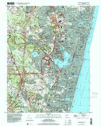
1995 Map of Asbury Park
USGS Topo · Published 2001About this map
Shark River defines the central topography of this Monmouth County coast, broadening into the South Arm before meeting the Atlantic Ocean at the Shark River Inlet. The landscape by the mid-1990s shows a dense network of coastal boroughs and inland developments, where older mill sites like Algers Mills and Osbones Mills contrast with modern infrastructure such as the Garden State Parkway. Large institutional and military holdings occupy the western reaches, notably the Earle Naval Weapons Station and the National Guard Training Center near the shore. Residential growth is visible in the suburban layouts of Hamilton, Glendola, and Spring Lake Heights, while historical burial grounds including Monmouth Mem Park (Cem) and Jump Brook Cem provide significant points of reference for genealogists tracking local families.
Find a feature on this map
98 named features on this map. Tap any name to fly to it.
Don’t see what you’re looking for? This feature index may not catch every label — zoom into the map to look around manually.
Map Details
Editions of this 1995 Asbury Park Map
This is the sole edition of this map. No revisions or reprints were ever made.
Other maps of this area

1888 · Asbury Park
USGS Topo · 1:62,500

1888 · Sandy Hook
USGS Topo · 1:62,500

1893 · Sandy Hook
USGS Topo · 1:62,500

1893 · Asbury Park
USGS Topo · 1:62,500

1901 · Sandy Hook
USGS Topo · 1:62,500

1901 · Asbury Park
USGS Topo · 1:62,500

1902 · Navesink
USGS Topo · 1:125,000

1918 · Sandy Hook
USGS Topo · 1:62,500

1919 · Asbury Park
USGS Topo · 1:62,500

1942 · Farmingdale
USGS Topo · 1:24,000