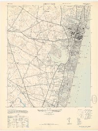
1947 Map of Asbury Park
USGS Topo · Published 1947About this map
The Jersey Shore's mid-century coastal character is preserved here, centered on the dense urban grid of Asbury Park and its landmark Convention Hall. The map documents a time when distinct borough boundaries like Ocean Grove, Bradley Beach, and Avon maintained their individual identities even as development pressed inland. Beyond the boardwalks and beachfronts, the landscape shifts toward agricultural and industrial sites, including the Fred McDowell Sand & Gravel operations and the sprawling military reservation boundaries. Genealogists will find significant detail in the numerous burial grounds and civic institutions, ranging from Temple Beth El Cem to the Mt Prospect Cemetery. The inclusion of smaller crossroads like Shafto Corners and Reevytown provides a window into the rural hinterland of Monmouth County before the post-war suburban surge fully transformed the region's interior.
Find a feature on this map
89 named features on this map. Tap any name to fly to it.
Don’t see what you’re looking for? This feature index may not catch every label — zoom into the map to look around manually.
Map Details
Editions of this 1947 Asbury Park Map
This is the sole edition of this map. No revisions or reprints were ever made.
Other maps of this area

1888 · Asbury Park
USGS Topo · 1:62,500

1888 · Sandy Hook
USGS Topo · 1:62,500

1893 · Sandy Hook
USGS Topo · 1:62,500

1893 · Asbury Park
USGS Topo · 1:62,500

1901 · Sandy Hook
USGS Topo · 1:62,500

1901 · Asbury Park
USGS Topo · 1:62,500

1902 · Navesink
USGS Topo · 1:125,000

1918 · Sandy Hook
USGS Topo · 1:62,500

1919 · Asbury Park
USGS Topo · 1:62,500

1942 · Farmingdale
USGS Topo · 1:24,000