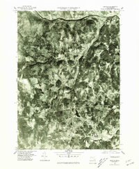
1975 Map of Ashfield
USGS Topo · Published 1981About this map
The Deerfield River forms the northern boundary of this high-contrast aerial landscape, where the wooded uplands of Franklin County meet the winding river valleys of the 1970s. This orthophotograph, captured by the Geological Survey and the Commonwealth of Massachusetts, reveals a settlement pattern defined by isolated village clusters and narrow valley roads. The rural centers of Ashfield and South Ashfield anchor the southern portion of the sheet, connected to the northern reaches of Buckland and East Charlemont by a network of steep terrain and watercourses. Unlike traditional topographic maps, this imagery provides a direct look at the mid-century land use, showing the exact footprint of forest cover and cleared fields surrounding Buckland Four Corners. Researchers can trace the influence of the Swift River and Bear River on the development of these small mountain communities.
Find a feature on this map
9 named features on this map. Tap any name to fly to it.
Don’t see what you’re looking for? This feature index may not catch every label — zoom into the map to look around manually.
Map Details
Editions of this 1975 Ashfield Map
This is the sole edition of this map. No revisions or reprints were ever made.
Other maps of this area

1885 · Northampton
USGS Topo · 1:62,500

1886 · Hawley
USGS Topo · 1:62,500

1886 · Chesterfield
USGS Topo · 1:62,500

1886 · Northampton
USGS Topo · 1:62,500

1888 · Chesterfield
USGS Topo · 1:62,500

1890 · Hawley
USGS Topo · 1:62,500

1890 · Greenfield
USGS Topo · 1:62,500

1891 · Northampton
USGS Topo · 1:62,500

1893 · Northampton
USGS Topo · 1:62,500

1893 · Chesterfield
USGS Topo · 1:62,500