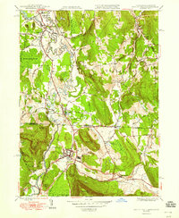
1948 Map of Ashley Falls
USGS Topo · Published 1948About this map
The Housatonic River meanders across the state line in this late 1940s survey, connecting the villages of Sheffield and Ashley Falls in Massachusetts with the industrial and rail hubs of Canaan and East Canaan in Connecticut. This area represents a critical junction for the New York New Haven and Hartford railroad, which follows the river valley and supports the local limestone and agricultural economy. The map preserves the names of early settlements like Sodom and Clayton, alongside numerous family-named landmarks such as Dutcher Hill, Miles Mtn, and Benton Hill. Local history is anchored by sites like Center Cem and the Canaan Landing Field, reflecting a period when small-town aviation and traditional rail transport coexisted. The landscape is defined by the steep rise of Canaan Mtn and the wetlands of the Barnum Street Swamp, illustrating the transition from the fertile valley floor to the forested uplands of the Berkshires and Litchfield Hills.
Find a feature on this map
48 named features on this map. Tap any name to fly to it.
Don’t see what you’re looking for? This feature index may not catch every label — zoom into the map to look around manually.
Map Details
Editions of this 1948 Ashley Falls Map
This is the sole edition of this map. No revisions or reprints were ever made.
Other maps of this area

1885 · Sheffield
USGS Topo · 1:62,500

1888 · Sheffield
USGS Topo · 1:62,500

1888 · Sandisfield
USGS Topo · 1:62,500

1891 · Sheffield
USGS Topo · 1:62,500

1892 · Winsted
USGS Topo · 1:62,500

1892 · Cornwall
USGS Topo · 1:62,500

1893 · Sheffield
USGS Topo · 1:62,500

1893 · Cornwall
USGS Topo · 1:62,500

1893 · Sandisfield
USGS Topo · 1:62,500

1897 · Sandisfield
USGS Topo · 1:62,500