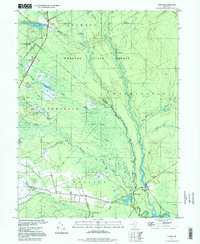
1997 Map of Atsion
USGS Topo · Published 1998About this map
Wharton State Forest dominates this Pine Barrens landscape, where the Mullica River and Batsto River converge amidst a network of intricate waterways and wetlands. The southern reaches of the map reveal a distinct cultural pocket at Batsto and Pleasant Mills, areas historically defined by their proximity to the water's power and early industrial development. Numerous Cranberry Bogs are scattered throughout the Great Swamp and along the Sleeper Branch, reflecting the region’s long-standing agricultural dependence on the acidic, sandy soil. Settled clusters such as Wescoatville and Nesco, complete with the Nesco Sch, show the inland community structure late in the 20th century. Notable landmarks include the Lookout Tower and historic crossing points like Quaker Bridge, which once served as vital links through this dense, wooded interior.
Find a feature on this map
49 named features on this map. Tap any name to fly to it.
Don’t see what you’re looking for? This feature index may not catch every label — zoom into the map to look around manually.
Map Details
Editions of this 1997 Atsion Map
This is the sole edition of this map. No revisions or reprints were ever made.
Other maps of this area

1888 · Pemberton
USGS Topo · 1:62,500

1888 · Mount Holly
USGS Topo · 1:62,500

1890 · Hammonton
USGS Topo · 1:62,500

1890 · Mullica
USGS Topo · 1:62,500

1894 · Hammonton
USGS Topo · 1:62,500

1894 · Pemberton
USGS Topo · 1:62,500

1894 · Mount Holly
USGS Topo · 1:62,500

1894 · Mullica
USGS Topo · 1:62,500

1898 · Pemberton
USGS Topo · 1:62,500

1898 · Mount Holly
USGS Topo · 1:62,500
Featured Places
- Hammonton, NJ
- Tabernacle Township, NJ
- Mullica Township, NJ
- Washington Township, NJ
- Waterford Township, NJ