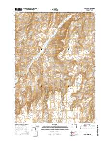
2014 Map of Avery Creek
USGS Topo · Published 2014About this map
Avery Creek and Sixteenmile Cr carve through this high desert portion of Malheur County, where the landscape is defined by an extensive network of artificial water catchments and isolated springs. The reliance on water management is evident in the numerous named basins, such as Petrified Reservoir, Good Place Reservoir, and Military Reservoir, which likely supported the region's livestock ranching economy. Settlement is sparse, with primary access provided by unpaved routes like Crowley Rd and Cottonwood Rd. Dramatic geological features including Black Canyon and Box Canyon break the terrain, while family-named or descriptive landmarks like Division Reservoir Chastain Spring and Knucklebone Reservoir provide specific points of interest for local historians and researchers tracking land use in the Oregon outback during the early 21st century.
Find a feature on this map
36 named features on this map. Tap any name to fly to it.
Don’t see what you’re looking for? This feature index may not catch every label — zoom into the map to look around manually.
Map Details
Editions of this 2014 Avery Creek Map
This is the sole edition of this map. No revisions or reprints were ever made.
Other maps of this area

1955 · Boise
USGS Topo · 1:250,000

1958 · Boise
USGS Topo · 1:250,000

1962 · Boise
USGS Topo · 1:250,000

1966 · Harper
USGS Topo · 1:62,500

1966 · Westfall Butte
USGS Topo · 1:62,500

1972 · Tims Peak
USGS Topo · 1:24,000

1972 · Alder Creek
USGS Topo · 1:24,000

1972 · Avery Creek
USGS Topo · 1:24,000

1972 · Rufino Butte
USGS Topo · 1:24,000
1972 · Hurley Flat
USGS Topo · 1:24,000