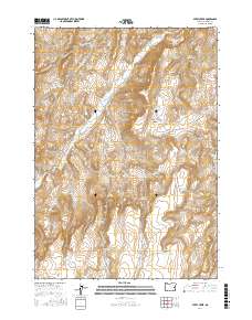
2017 Map of Avery Creek
USGS Topo · Published 2017About this map
Avery Creek flows through this high-elevation rangeland in Malheur County, where a complex network of springs and reservoirs supports the region's cattle-ranching heritage. The landscape is defined by drainage systems such as Cottonwood Cr and Sixteenmile Cr, which have carved deep features like Black Canyon and Box Canyon. Human impact on this arid terrain is most visible through a high concentration of water-management sites, ranging from the uniquely named Good Place Reservoir and Knucklebone Reservoir to family-named landmarks like O'Toole Reservoir and Chastain Spring. These water sources are connected by a few vital thoroughfares, including Crowley Rd and Keeney Creek Rd, which provide access to this isolated corner of Oregon. The map illustrates how essential specific, named water points are for navigating and utilizing the high desert terrain.
Find a feature on this map
39 named features on this map. Tap any name to fly to it.
Don’t see what you’re looking for? This feature index may not catch every label — zoom into the map to look around manually.
Map Details
Editions of this 2017 Avery Creek Map
This is the sole edition of this map. No revisions or reprints were ever made.
Other maps of this area

1955 · Boise
USGS Topo · 1:250,000

1958 · Boise
USGS Topo · 1:250,000

1962 · Boise
USGS Topo · 1:250,000

1966 · Harper
USGS Topo · 1:62,500

1966 · Westfall Butte
USGS Topo · 1:62,500

1972 · Tims Peak
USGS Topo · 1:24,000

1972 · Alder Creek
USGS Topo · 1:24,000

1972 · Avery Creek
USGS Topo · 1:24,000

1972 · Rufino Butte
USGS Topo · 1:24,000
1972 · Hurley Flat
USGS Topo · 1:24,000