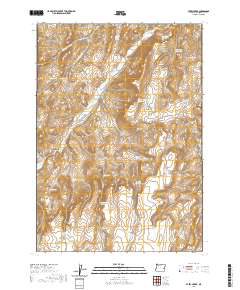
2020 Map of Avery Creek
USGS Topo · Published 2020About this map
Avery Creek winds through this high desert region of Malheur County, where the management of water is the primary signature on the land. A network of reservoirs, including the aptly named Good Place Reservoir and Knucklebone Reservoir, demonstrates the essential infrastructure required for ranching and survival in this arid environment. The landscape is defined by its drainages, such as Black Canyon and Box Canyon, which dictate the paths of primitive routes like Crowley Rd and Cottonwood Rd. Scattered springs such as Cottonwood Cabin Spring and Gacey Spring provide small oases in the sagebrush-covered terrain. The presence of features like Military Reservoir and Division Reservoir suggests a history of land management and shared resources among the area's inhabitants. This survey provides a clear view of the drainage patterns and the specific, often family-named water sources that sustain life in this corner of Oregon.
Find a feature on this map
39 named features on this map. Tap any name to fly to it.
Don’t see what you’re looking for? This feature index may not catch every label — zoom into the map to look around manually.
Map Details
Editions of this 2020 Avery Creek Map
This is the sole edition of this map. No revisions or reprints were ever made.
Other maps of this area

1955 · Boise
USGS Topo · 1:250,000

1958 · Boise
USGS Topo · 1:250,000

1962 · Boise
USGS Topo · 1:250,000

1966 · Harper
USGS Topo · 1:62,500

1966 · Westfall Butte
USGS Topo · 1:62,500

1972 · Tims Peak
USGS Topo · 1:24,000

1972 · Alder Creek
USGS Topo · 1:24,000

1972 · Avery Creek
USGS Topo · 1:24,000

1972 · Rufino Butte
USGS Topo · 1:24,000
1972 · Hurley Flat
USGS Topo · 1:24,000