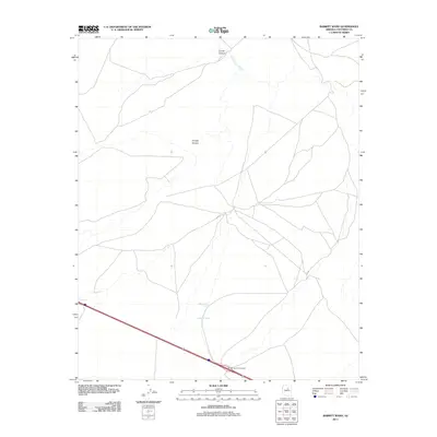
2011 Map of Babbitt Wash
USGS Topo · Published 2011About this map
Babbitt Wash and San Francisco Wash define the drainage patterns across this High Desert landscape in central Coconino County. The terrain is characterized by broad alluvial plains and seasonal watercourses, with notable landforms including Locust Canyon in the north and Youngs Canyon near the center. Infrastructure in this sparsely populated region is concentrated along the southern corridor, where the modern interstate network passes through. The presence of the Buffalo Road Interchange reflects the area's role as a transit point between regional hubs, while the surrounding web of local roads and trails suggests a continuing reliance on ranching or land management activities. The map provides a precise look at the 2011 topography, capturing a moment when the rural character of the land remains largely intact despite the presence of major transportation arteries.
Find a feature on this map
5 named features on this map. Tap any name to fly to it.
Don’t see what you’re looking for? This feature index may not catch every label — zoom into the map to look around manually.
Map Details
Editions of this 2011 Babbitt Wash Map
This is the sole edition of this map. No revisions or reprints were ever made.
Other maps of this area

1886 · San Francisco Mtns
USGS Topo · 1:250,000

1891 · San Francisco Mtns
USGS Topo · 1:250,000

1894 · San Francisco Mtns
USGS Topo · 1:250,000

1899 · San Francisco Mtns
USGS Topo · 1:250,000

1947 · Flagstaff
USGS Topo · 1:250,000

1954 · Flagstaff
USGS Topo · 1:250,000

1958 · Flagstaff
USGS Topo · 1:250,000

1960 · Flagstaff
USGS Topo · 1:250,000

1962 · Flagstaff
USGS Topo · 1:250,000
1968 · Elliott Canyon
USGS Topo · 1:24,000