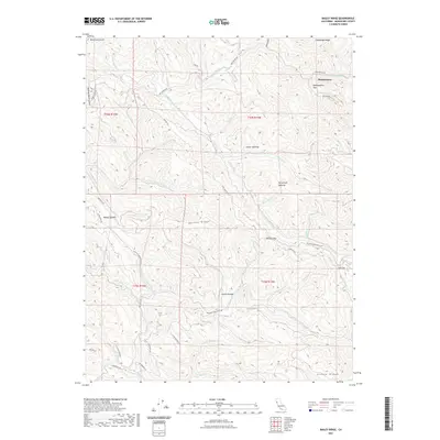
2021 Map of Bailey Ridge
USGS Topo · Published 2021About this map
Montgomery park and the surrounding timberlands of Mendocino County define this upland landscape, where the headwaters of the S Fork Big River and the Little N Fork Navarro River drain divergent mountain slopes. The geography is marked by a complex network of ridges, including Bailey Ridge and Alaska Ridge, which are traversed by essential logging and transport corridors such as the Masonite Industrial Rd. The intersection of industrial utility and homesteading history is evident in named landmarks like Scott Homestead Rd and geographic waypoints like Wohlys Pass and Low Gap. This area serves as a critical watershed, with numerous named streams such as Daugherty Cr and Shingle Mill Cr carving through the terrain. The presence of Castle Garden and Montgomery Flat suggests early points of local interest or seasonal settlement within these dense California woodlands.
Find a feature on this map
52 named features on this map. Tap any name to fly to it.
Don’t see what you’re looking for? This feature index may not catch every label — zoom into the map to look around manually.
Map Details
Editions of this 2021 Bailey Ridge Map
This is the sole edition of this map. No revisions or reprints were ever made.
Other maps of this area

1920 · Glenblair
USGS Topo · 1:62,500

1922 · Willits
USGS Topo · 1:62,500

1942 · Willits
USGS Topo · 1:62,500

1943 · Glenblair
USGS Topo · 1:62,500

1943 · Boonville
USGS Topo · 1:62,500

1943 · Navarro
USGS Topo · 1:62,500

1944 · Willits
USGS Topo · 1:62,500

1944 · Saddle Point
USGS Topo · 1:62,500

1957 · Ukiah
USGS Topo · 1:250,000
1959 · Boonville
USGS Topo · 1:62,500