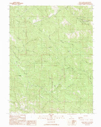
1991 Map of Bailey Ridge
USGS Topo · Published 1991About this map
Montgomery Woods State Reserve preserves a significant pocket of old-growth landscape in this 1991 survey of the coastal range. The map documents the transition from the South Fork Big River drainage in the north to the Little North Fork Navarro River system in the south. These steep, timbered ridges are punctuated by small clearings and historical sites such as the Old Wright Place and Old Bailey Place, indicating a history of isolated homesteading and ranching. The presence of features like the Corral and Gates near Squaw Opening suggests a land-use pattern centered on grazing and forestry. Named topographic features like Wehlys Pass and Castle Garden provide specific landmarks for those tracing the historical geography of these interior ridges.
Find a feature on this map
36 named features on this map. Tap any name to fly to it.
Don’t see what you’re looking for? This feature index may not catch every label — zoom into the map to look around manually.
Map Details
Editions of this 1991 Bailey Ridge Map
This is the sole edition of this map. No revisions or reprints were ever made.
Other maps of this area

1920 · Glenblair
USGS Topo · 1:62,500

1922 · Willits
USGS Topo · 1:62,500

1942 · Willits
USGS Topo · 1:62,500

1943 · Glenblair
USGS Topo · 1:62,500

1943 · Boonville
USGS Topo · 1:62,500

1943 · Navarro
USGS Topo · 1:62,500

1944 · Willits
USGS Topo · 1:62,500

1944 · Saddle Point
USGS Topo · 1:62,500

1957 · Ukiah
USGS Topo · 1:250,000
1959 · Boonville
USGS Topo · 1:62,500