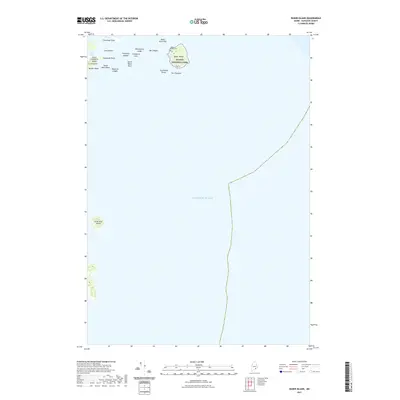
2021 Map of Baker Island
USGS Topo · Published 2021About this map
Baker Island and its surrounding archipelago anchor this coastal Maine survey, situated within the southeastern boundaries of Acadia National Park. The maritime geography is characterized by a series of rocky outcroppings and ledges, including Whitehorse Ledge and the Mackerel Ledges, which delineate the hazardous navigation routes through the Atlantic Ocean. On the southern tip of Great Cranberry Island, the landscape rises toward Dolly Hill and Bunker Head, overlooking the sheltered waters of The Pool. A small historic burial site, the Baker Island Cem, is located on the northern end of its namesake island near the Baker Island Bar. This 2021 update documents the enduring landforms and conservation boundaries of the Cranberry Isles, from the northern reach of Crow Island to the isolated southern outpost of Little Duck Island.
Find a feature on this map
23 named features on this map. Tap any name to fly to it.
Don’t see what you’re looking for? This feature index may not catch every label — zoom into the map to look around manually.
Map Details
Editions of this 2021 Baker Island Map
This is the sole edition of this map. No revisions or reprints were ever made.
Other maps of this area

1904 · Mount Desert
USGS Topo · 1:62,500

1904 · Swan Island
USGS Topo · 1:62,500

1904 · Bar Harbor
USGS Topo · 1:62,500

1942 · Bar Harbor
USGS Topo · 1:62,500

1942 · Mount Desert
USGS Topo · 1:62,500

1943 · Swans Island
USGS Topo · 1:62,500

1945 · Swans Island
USGS Topo · 1:62,500

1948 · Bangor
USGS Topo · 1:250,000

1956 · Bar Harbor
USGS Topo · 1:62,500

1956 · Mount Desert
USGS Topo · 1:62,500