1938 Map of Baldwin Gap
USGS Topo · Published 1957About this map
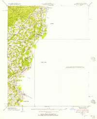
The Tennessee and North Carolina border runs through this 1938 survey, following the high ridges of Stone Mountain and Willen Mountain. This area, deeply integrated into the Cherokee National Forest, shows a landscape defined by isolated homesteads and small communities connected by winding mountain roads. The geography is marked by numerous gaps, including Baldwin Gap and Amber Gap, which served as critical passage points between Johnson Co and Ashe Co.
Find a feature on this map
57 named features on this map. Tap any name to fly to it.
Don’t see what you’re looking for? This feature index may not catch every label — zoom into the map to look around manually.
Map Details
Editions of this 1938 Baldwin Gap Map
This is the sole edition of this map. No revisions or reprints were ever made.
Other maps of this area

1891 · Abingdon
USGS Topo · 1:125,000

1893 · Cranberry
USGS Topo · 1:125,000

1894 · Abingdon
USGS Topo · 1:125,000

1895 · Cranberry
USGS Topo · 1:125,000

1899 · Cranberry
USGS Topo · 1:125,000

1902 · Cranberry
USGS Topo · 1:125,000

1909 · Abingdon
USGS Topo · 1:96,000

1911 · Abingdon
USGS Topo · 1:125,000

1935 · Grayson
USGS Topo · 1:24,000

1935 · Park
USGS Topo · 1:24,000