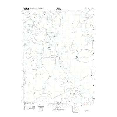
2012 Map of Bangor
USGS Topo · Published 2012About this map
Bangor and the smaller settlement of Hurleton anchor the southeast and northeast corners of this Butte County landscape, which is defined by an intricate network of waterways and ravines. The terrain is marked by a transition from the lower reaches of Wyandotte toward the higher elevations of Phoenix Hill and Rattlesnake Point. Crucial water infrastructure, including the Palermo Canal, South Ditch, and Henderson Ditch, illustrates the area's long-standing reliance on irrigation for agriculture and mining operations. Numerous named drainages like Fine Gold Gulch, Irish Ravine, and Whitehall Ravine carve through the foothills, hinting at the regional history of gold prospecting. Notable topographic landmarks such as Cleveland Hill and Katskill Hill provide context for the scattered residential developments and the winding paths of the Oro Bangor Hwy and Forbestown Rd that connect these rural communities.
Find a feature on this map
111 named features on this map. Tap any name to fly to it.
Don’t see what you’re looking for? This feature index may not catch every label — zoom into the map to look around manually.
Map Details
Editions of this 2012 Bangor Map
This is the sole edition of this map. No revisions or reprints were ever made.
Other maps of this area

1888 · Marysville
USGS Topo · 1:125,000

1888 · Smartsville
USGS Topo · 1:125,000

1888 · Bidwell Bar
USGS Topo · 1:125,000

1891 · Bidwell Bar
USGS Topo · 1:125,000

1891 · Chico
USGS Topo · 1:125,000

1891 · Marysville
USGS Topo · 1:125,000

1891 · Smartsville
USGS Topo · 1:125,000

1892 · Smartsville
USGS Topo · 1:125,000

1893 · Chico
USGS Topo · 1:125,000

1893 · Bidwell Bar
USGS Topo · 1:125,000