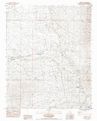
1984 Map of Bannock
USGS Topo · Published 1984About this map
Bannock and Goffs serve as key stops along the Atchison Topeka and Santa Fe Railroad corridor in this high desert landscape of the early 1980s. The region is defined by the convergence of the Sacramento Mountains and the Dead Mountains, with the broad expanse of the Piute Valley stretching between them. The railroad's path is closely shadowed by the massive drainage of the Sacramento Wash, a network of seasonal watercourses that include Piute Wash and the smaller Hacienda Wash. Evidence of utility infrastructure is prominent throughout the terrain, with several marked stretches of Underground Gas Pipeline and an Abandoned Reservoir. Further east, the small settlement of Klinefelter is noted near Sacramento Springs, highlighting the importance of even minor water sources in this arid environment.
Find a feature on this map
24 named features on this map. Tap any name to fly to it.
Don’t see what you’re looking for? This feature index may not catch every label — zoom into the map to look around manually.
Map Details
Editions of this 1984 Bannock Map
This is the sole edition of this map. No revisions or reprints were ever made.
Other maps of this area

1886 · Camp Mohave
USGS Topo · 1:250,000

1892 · Camp Mohave
USGS Topo · 1:250,000

1903 · Needles
USGS Topo · 1:125,000

1904 · Needles Special
USGS Topo · 1:125,000

1926 · Mohave City
USGS Topo · 1:96,000

1942 · Camp Mohave
USGS Topo · 1:250,000

1943 · Bannock
USGS Topo · 1:62,500

1947 · Kingman
USGS Topo · 1:250,000

1948 · Kingman
USGS Topo · 1:250,000

1950 · Davis Dam
USGS Topo · 1:62,500