
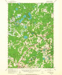
1956 Map of Barnum
USGS Topo · Published 1958About this map
The Northern Pacific railroad corridor dictates the settlement pattern of this Carlton County landscape, linking the communities of Sawyer, Atkinson, Mahtowa, and Barnum in a diagonal line. To the north, the Fond Du Lac Indian Reservation Boundary encompasses a dense network of water bodies, including Rice Portage Lake, Perch Lake, and Big Lake. Local life is anchored by small rural institutions such as the Mary and Joseph Ch and Big Lake Chapel, alongside the Salem Cem and Blackhoof Valley Sch. The presence of the Cloquet Forest Experiment Station and Cloquet Municipal Airport near the northern edge highlights the region's mid-century intersection of forestry research and transportation. This survey reflects a period of established township boundaries like Skelton and Blackhoof and the quiet persistence of family-named landmarks and country churches across the northern woods.
Find a feature on this map
65 named features on this map. Tap any name to fly to it.
Don’t see what you’re looking for? This feature index may not catch every label — zoom into the map to look around manually.
Map Details
Editions of this 1956 Barnum Map
2 editions found
Other maps of this area

1949 · Holyoke
USGS Topo · 1:48,000

1953 · Saginaw
USGS Topo · 1:24,000

1953 · Brookston
USGS Topo · 1:24,000

1953 · Duluth
USGS Topo · 1:250,000

1954 · Cloquet
USGS Topo · 1:24,000

1954 · Wrenshall
USGS Topo · 1:24,000

1954 · Atkinson
USGS Topo · 1:24,000

1954 · Iverson
USGS Topo · 1:24,000

1954 · Sawyer
USGS Topo · 1:24,000

1954 · Martin Lake
USGS Topo · 1:24,000