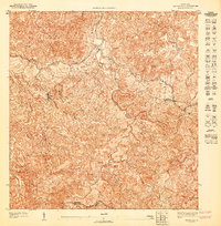
1947 Map of Bayaney SE
USGS Topo · Published 1947About this map
Municipio Utuado and Municipio Adjuntas meet along a complex boundary defined by sharp ridgelines and deep river valleys in this mid-century preliminary survey. The settlement of Angeles occupies a high-elevation position in the western portion of the quadrangle, connected by a winding network of mountain roads and private trails. The landscape is characterized by its dramatic drainage patterns, including the prominent courses of Tanama, Pasto, and various Quebradas that cut through the steep topography. Educational infrastructure of the era is represented by the Escuela Segunda Unidad de Caguana, a significant local landmark. This 1940s topography captures the rural character of central Puerto Rico before modern development, detailing the distribution of individual buildings and dwellings throughout the mountain slopes and narrow valleys.
Find a feature on this map
8 named features on this map. Tap any name to fly to it.
Don’t see what you’re looking for? This feature index may not catch every label — zoom into the map to look around manually.
Map Details
Editions of this 1947 Bayaney SE Map
This is the sole edition of this map. No revisions or reprints were ever made.
Other maps of this area

1946 · Utuado
USGS Topo · 1:30,000

1946 · Bayaney
USGS Topo · 1:30,000

1946 · Monte Guilarte
USGS Topo · 1:30,000

1946 · Adjuntas
USGS Topo · 1:30,000
1947 · Monte Guilarte NE
USGS Topo · 1:10,000
1947 · Adjuntas NO
USGS Topo · 1:10,000
1947 · Utuado SO
USGS Topo · 1:10,000
1947 · Monte Guilarte NO
USGS Topo · 1:10,000
1947 · Utuado NO
USGS Topo · 1:10,000
1947 · Bayaney NE
USGS Topo · 1:10,000