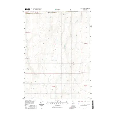
2015 Map of Bear Mountain
USGS Topo · Published 2015About this map
Humboldt National Forest spans the western portion of this high-desert landscape along the Idaho and Nevada border. The rugged topography is defined by the central prominence of Bear Mtn and an intricate drainage system including N Fork Salmon Falls Cr, Shack Cr, and Wilson Cr. This area in Twin Falls County and Elko County remains largely undeveloped, with Cottonwood Field in the southeast corner representing a rare named clearing or pasture in the canyon-laced terrain. Primitive routes like CR-753 provide the only access through these high-altitude draws. The map illustrates the complex hydrography where multiple seasonal streams, such as Lime Cr and Shell Cr, carve through the plateau, showcasing the remote character of the Great Basin's northern edge during the early 21st century.
Find a feature on this map
19 named features on this map. Tap any name to fly to it.
Don’t see what you’re looking for? This feature index may not catch every label — zoom into the map to look around manually.
Map Details
Editions of this 2015 Bear Mountain Map
This is the sole edition of this map. No revisions or reprints were ever made.
Other maps of this area

1955 · Twin Falls
USGS Topo · 1:250,000

1955 · Wells
USGS Topo · 1:250,000

1957 · Contact
USGS Topo · 1:62,500

1957 · Elk Mountain
USGS Topo · 1:62,500

1958 · Wells
USGS Topo · 1:250,000

1958 · Twin Falls
USGS Topo · 1:250,000

1961 · Wells
USGS Topo · 1:250,000

1977 · Browns Bench South
USGS Topo · 1:24,000

1978 · Taylor Canyon
USGS Topo · 1:24,000
1980 · Curtis Draw
USGS Topo · 1:24,000