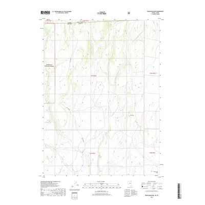
2018 Map of Bear Mountain
USGS Topo · Published 2018About this map
Bear Mtn rises above a complex drainage system at the border of Idaho and Nevada, where high-desert ranching country meets the northeastern edge of the Humboldt National Forest. The landscape is defined by the South-to-North flow of the N Fork Salmon Falls Cr, which is fed by numerous tributaries including Shack Cr, Bear Cr, and Shell Cr. These water sources were vital for the development of remote outposts like Cottonwood Field in the southeastern corner of the quadrangle.
Find a feature on this map
19 named features on this map. Tap any name to fly to it.
Don’t see what you’re looking for? This feature index may not catch every label — zoom into the map to look around manually.
Map Details
Editions of this 2018 Bear Mountain Map
This is the sole edition of this map. No revisions or reprints were ever made.
Other maps of this area

1955 · Twin Falls
USGS Topo · 1:250,000

1955 · Wells
USGS Topo · 1:250,000

1957 · Contact
USGS Topo · 1:62,500

1957 · Elk Mountain
USGS Topo · 1:62,500

1958 · Wells
USGS Topo · 1:250,000

1958 · Twin Falls
USGS Topo · 1:250,000

1961 · Wells
USGS Topo · 1:250,000

1977 · Browns Bench South
USGS Topo · 1:24,000

1978 · Taylor Canyon
USGS Topo · 1:24,000
1980 · Curtis Draw
USGS Topo · 1:24,000