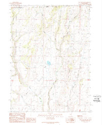
1989 Map of Bear Mountain
USGS Topo · Published 1989About this map
O'Neil Basin defines the high-altitude landscape of this remote border region between Nevada and Idaho in the late 1980s. The topography is dominated by the steep slopes of Bear Mountain and the western edge of the Humboldt National Forest, which gives way to a complex network of high-desert drainage systems. The North Fork Salmon Falls Creek and Bear Creek are central to the hydrology of the area, accompanied by numerous smaller seasonal flows like Shack Creek, Shell Creek, and Wilson Creek. Evidence of ranching operations in this isolated terrain is found at the Gully Ranch, situated along the lower elevations of the basin. The map captures the meeting point of Elko County and Twin Falls County, where the state line crosses through a landscape shaped by intermittent water sources such as Lime Creek and Willow Creek, reflecting the traditional land use and drainage patterns of the Great Basin's northeastern edge.
Find a feature on this map
14 named features on this map. Tap any name to fly to it.
Don’t see what you’re looking for? This feature index may not catch every label — zoom into the map to look around manually.
Map Details
Editions of this 1989 Bear Mountain Map
This is the sole edition of this map. No revisions or reprints were ever made.
Other maps of this area

1955 · Twin Falls
USGS Topo · 1:250,000

1955 · Wells
USGS Topo · 1:250,000

1957 · Contact
USGS Topo · 1:62,500

1957 · Elk Mountain
USGS Topo · 1:62,500

1958 · Wells
USGS Topo · 1:250,000

1958 · Twin Falls
USGS Topo · 1:250,000

1961 · Wells
USGS Topo · 1:250,000

1977 · Browns Bench South
USGS Topo · 1:24,000

1978 · Taylor Canyon
USGS Topo · 1:24,000
1980 · Curtis Draw
USGS Topo · 1:24,000