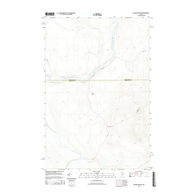
2014 Map of Beaver Pond SE
USGS Topo · Published 2014About this map
The Saint John River carves through this northern Maine landscape, serving as the border between Aroostook and Somerset Counties. This 2014 survey captures a region defined by commercial timberlands and remote watercourses, where industry access is provided by a network of private forest roads like Reality Rd and Depot Rd. Crossing the river near Ledge Rapids is Moody Bridge, a vital connector in this otherwise unpopulated stretch of the North Maine Woods. In the southern portion of the quadrangle, the Southwest Branch Saint John River winds through lower elevations, while Ross Mtn rises to the east. Several smaller tributaries, including Burntland Brook and Knowles Brook, drain the high ground, illustrating the complex hydrology that has shaped the region's logging history and river-driving heritage.
Find a feature on this map
12 named features on this map. Tap any name to fly to it.
Don’t see what you’re looking for? This feature index may not catch every label — zoom into the map to look around manually.
Map Details
Editions of this 2014 Beaver Pond SE Map
This is the sole edition of this map. No revisions or reprints were ever made.
Other maps of this area

1954 · Baker Lake
USGS Topo · 1:62,500

1954 · Allagash Lake
USGS Topo · 1:62,500

1954 · Presque Isle
USGS Topo · 1:250,000

1955 · Beaver Pond
USGS Topo · 1:62,500

1955 · Clayton Lake
USGS Topo · 1:62,500

1958 · Presque Isle
USGS Topo · 1:250,000

1960 · Presque Isle
USGS Topo · 1:250,000

1961 · Allagash Lake
USGS Topo · 1:62,500

1962 · Baker Lake
USGS Topo · 1:62,500
1977 · Burntland Pond
USGS Topo · 1:24,000