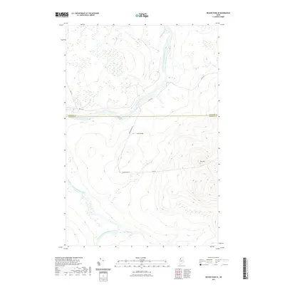
2021 Map of Beaver Pond SE
USGS Topo · Published 2021About this map
The Saint John River defines the upper portion of this northern Maine landscape, flowing past the Ledge Rapids at the border of Aroostook and Somerset Counties. This timber-rich territory is dominated by a network of private logging infrastructure, including Realty Rd, Depot Rd, and Ross Mountain Rd. To the south, the Southwest Branch Saint John River winds through the wetlands, joined by Knowles Brook in a largely unsettled wilderness area. Topographical interest centers on Ross Mtn, which rises above the surrounding forest near Goop Rd. The crossing at Moody Bridge serves as a critical point for transit through this working forest, where the topography transitions from river valleys to more prominent upland peaks.
Find a feature on this map
12 named features on this map. Tap any name to fly to it.
Don’t see what you’re looking for? This feature index may not catch every label — zoom into the map to look around manually.
Map Details
Editions of this 2021 Beaver Pond SE Map
This is the sole edition of this map. No revisions or reprints were ever made.
Other maps of this area

1954 · Baker Lake
USGS Topo · 1:62,500

1954 · Allagash Lake
USGS Topo · 1:62,500

1954 · Presque Isle
USGS Topo · 1:250,000

1955 · Beaver Pond
USGS Topo · 1:62,500

1955 · Clayton Lake
USGS Topo · 1:62,500

1958 · Presque Isle
USGS Topo · 1:250,000

1960 · Presque Isle
USGS Topo · 1:250,000

1961 · Allagash Lake
USGS Topo · 1:62,500

1962 · Baker Lake
USGS Topo · 1:62,500
1977 · Burntland Pond
USGS Topo · 1:24,000