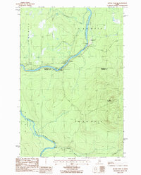
1986 Map of Beaver Pond SE
USGS Topo · Published 1986About this map
The St John River snakes through this remote borderland between Somerset and Aroostook counties, joined here by the Southwest Branch St John River. In the mid-1980s, this landscape was defined by its industrial timber access and recreational transit rather than permanent settlement, featuring a network of private roads and basic outposts. Notable riverside landmarks include the Red Pine Grove Campsite and the Red Pine Grove Landing Strip, which served as critical access points for the region.
Find a feature on this map
19 named features on this map. Tap any name to fly to it.
Don’t see what you’re looking for? This feature index may not catch every label — zoom into the map to look around manually.
Map Details
Editions of this 1986 Beaver Pond SE Map
This is the sole edition of this map. No revisions or reprints were ever made.
Other maps of this area

1954 · Baker Lake
USGS Topo · 1:62,500

1954 · Allagash Lake
USGS Topo · 1:62,500

1954 · Presque Isle
USGS Topo · 1:250,000

1955 · Beaver Pond
USGS Topo · 1:62,500

1955 · Clayton Lake
USGS Topo · 1:62,500

1958 · Presque Isle
USGS Topo · 1:250,000

1960 · Presque Isle
USGS Topo · 1:250,000

1961 · Allagash Lake
USGS Topo · 1:62,500

1962 · Baker Lake
USGS Topo · 1:62,500
1977 · Burntland Pond
USGS Topo · 1:24,000