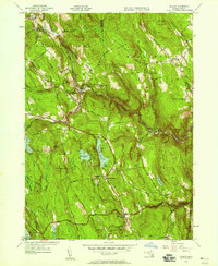
1945 Map of Becket
USGS Topo · Published 1958About this map
Becket and the surrounding Berkshire highlands are defined by a landscape of high summits and narrow river valleys as they appeared following the Second World War. The West Branch Westfield River cuts a deep path through the center of the sheet, followed closely by the tracks of the Boston & Albany RR. This rail corridor was the lifeblood of settlements like Bancroft and Becket, connecting the upland quarries and mills to the larger markets of New England.
Find a feature on this map
53 named features on this map. Tap any name to fly to it.
Don’t see what you’re looking for? This feature index may not catch every label — zoom into the map to look around manually.
Map Details
Editions of this 1945 Becket Map
This is the sole edition of this map. No revisions or reprints were ever made.
Other maps of this area

1886 · Chesterfield
USGS Topo · 1:62,500

1886 · Becket
USGS Topo · 1:62,500

1887 · Granville
USGS Topo · 1:62,500

1888 · Becket
USGS Topo · 1:62,500

1888 · Sandisfield
USGS Topo · 1:62,500

1888 · Chesterfield
USGS Topo · 1:62,500

1889 · Granville
USGS Topo · 1:62,500

1893 · Granville
USGS Topo · 1:62,500

1893 · Chesterfield
USGS Topo · 1:62,500

1893 · Becket
USGS Topo · 1:62,500