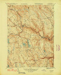
1948 Map of Becket
USGS Topo · Published 1948About this map
Becket and the surrounding Berkshire highlands are defined here by a rugged landscape where the West Branch Westfield River and the Boston and Albany railroad corridor dictate the flow of commerce and settlement. In the late 1940s, the region displays a clear transition from industrial riverfront hubs to upland agricultural centers. The map documents significant local landmarks such as the Mt St Lawrence Novitiate and the Washington Cem, providing valuable context for those researching family ties in Middlefield or Washington. Transportation networks are prominent, featuring the historic Jacobs Ladder route and numerous mountain roads connecting isolated homesteads to Middlefield Sta and Bancroft. Water bodies like Center Pond, Yokum Pond, and Rudd Pond punctuate the high terrain, while the convergence of three counties—Hampshire, Berkshire, and Hampden—adds a layer of jurisdictional detail for regional historians.
Find a feature on this map
45 named features on this map. Tap any name to fly to it.
Don’t see what you’re looking for? This feature index may not catch every label — zoom into the map to look around manually.
Map Details
Editions of this 1948 Becket Map
2 editions found
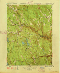
Other maps of this area

1886 · Chesterfield
USGS Topo · 1:62,500

1886 · Becket
USGS Topo · 1:62,500

1887 · Granville
USGS Topo · 1:62,500

1888 · Becket
USGS Topo · 1:62,500

1888 · Sandisfield
USGS Topo · 1:62,500

1888 · Chesterfield
USGS Topo · 1:62,500

1889 · Granville
USGS Topo · 1:62,500

1893 · Granville
USGS Topo · 1:62,500

1893 · Chesterfield
USGS Topo · 1:62,500

1893 · Becket
USGS Topo · 1:62,500