
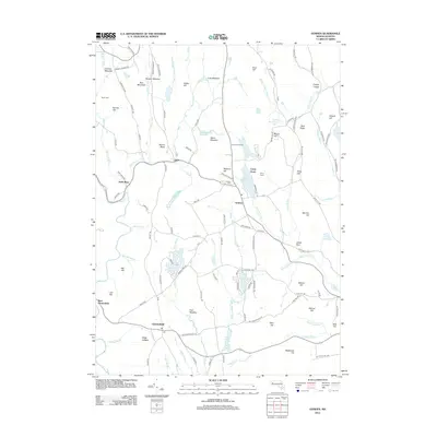
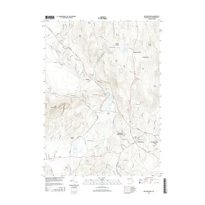
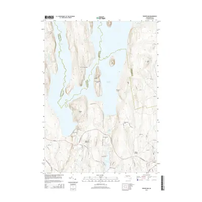
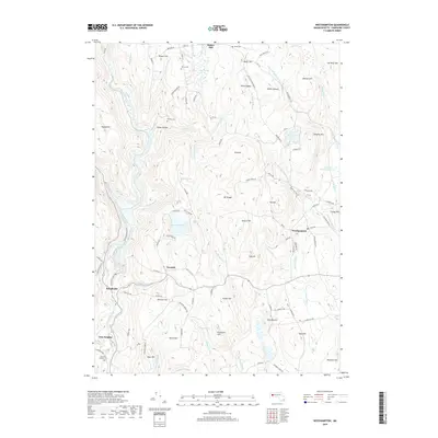
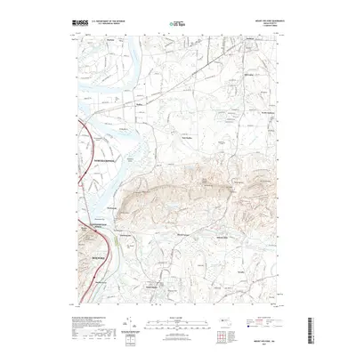
1890 Map of Belchertown
USGS Topo · Published 1890About this map
The Swift River valley and its complex network of tributaries dominate this late nineteenth-century landscape, decades before the geography of central Massachusetts was fundamentally altered. In this era, the valley is a series of active townships, including Enfield, Greenwich, and Prescott, where industry and agriculture followed the river's path. Rail transit was central to the region’s economy, with the Boston & Albany R. R. following the river corridor and the New London Northern R. R. cutting through Belchertown and past Dwights Station. Small industrial hamlets such as Greenwich Village and Smiths Village are documented alongside notable terrain features like Quabin Hill and the Mt. Holyoke Range. This survey preserves the exact locations of many settlements and homesteads that defined the upper river valley before the twentieth century.
Find a feature on this map
83 named features on this map. Tap any name to fly to it.
Don’t see what you’re looking for? This feature index may not catch every label — zoom into the map to look around manually.
Map Details
Editions of this 1890 Belchertown Map
This is the sole edition of this map. No revisions or reprints were ever made.
Historical Maps of Amherst Through Time
78 maps found

1886 Chesterfield
Hampshire County, MA

1887 Belchertown
Hampshire County, MA

1888 Chesterfield
Hampshire County, MA
1890 Belchertown
Hampshire County, MA

1893 Belchertown
Hampshire County, MA

1893 Chesterfield
Hampshire County, MA

1895 Chesterfield
Hampshire County, MA

1935 Easthampton
Hampshire County, MA

1935 Mt Holyoke
Hampshire County, MA

1939 Easthampton
Hampshire County, MA

1941 Mt Holyoke
Hampshire County, MA

1942 Belchertown
Hampshire County, MA

1943 Belchertown
Hampshire County, MA

1944 Winsor Dam
Hampshire County, MA

1946 Westhampton
Hampshire County, MA

1946 Worthington
Hampshire County, MA

1947 Mt Holyoke
Hampshire County, MA

1947 Westhampton
Hampshire County, MA

1948 Easthampton
Hampshire County, MA

1948 Goshen
Hampshire County, MA

1948 Mt Holyoke
Hampshire County, MA

1949 Belchertown
Hampshire County, MA

1952 Winsor Dam
Hampshire County, MA

1955 Goshen
Hampshire County, MA

1955 Westhampton
Hampshire County, MA

1956 Worthington
Hampshire County, MA

1964 Belchertown
Hampshire County, MA

1964 Easthampton
Hampshire County, MA

1964 Mt Holyoke
Hampshire County, MA

1967 Winsor Dam
Hampshire County, MA

1972 Goshen
Hampshire County, MA

1972 Westhampton
Hampshire County, MA

1972 Worthington
Hampshire County, MA

1975 Belchertown
Hampshire County, MA

1975 Easthampton
Hampshire County, MA

1975 Goshen
Hampshire County, MA

1975 Westhampton
Hampshire County, MA

1975 Winsor Dam
Hampshire County, MA

1975 Worthington
Hampshire County, MA

1987 Chester
Hampshire County, MA

1990 Goshen
Hampshire County, MA

1997 Chester
Hampshire County, MA

1997 Goshen
Hampshire County, MA

2012 Belchertown
Hampshire County, MA

2012 Easthampton
Hampshire County, MA
2012 Goshen
Hampshire County, MA
2012 Mount Holyoke
Hampshire County, MA
2012 Westhampton
Hampshire County, MA

2012 Winsor Dam
Hampshire County, MA
2012 Worthington
Hampshire County, MA
2015 Belchertown
Hampshire County, MA

2015 Easthampton
Hampshire County, MA
2015 Goshen
Hampshire County, MA
2015 Mount Holyoke
Hampshire County, MA
2015 Westhampton
Hampshire County, MA
2015 Winsor Dam
Hampshire County, MA

2015 Worthington
Hampshire County, MA
2018 Belchertown
Hampshire County, MA

2018 Easthampton
Hampshire County, MA
2018 Goshen
Hampshire County, MA
2018 Mount Holyoke
Hampshire County, MA
2018 Westhampton
Hampshire County, MA
2018 Winsor Dam
Hampshire County, MA
2018 Worthington
Hampshire County, MA
2021 Belchertown
Hampshire County, MA

2021 Easthampton
Hampshire County, MA

2021 Goshen
Hampshire County, MA
2021 Mount Holyoke
Hampshire County, MA
2021 Westhampton
Hampshire County, MA

2021 Winsor Dam
Hampshire County, MA

2021 Worthington
Hampshire County, MA

2024 Belchertown
Hampshire County, MA

2024 Easthampton
Hampshire County, MA

2024 Goshen
Hampshire County, MA

2024 Mount Holyoke
Hampshire County, MA

2024 Westhampton
Hampshire County, MA

2024 Winsor Dam
Hampshire County, MA

2024 Worthington
Hampshire County, MA