1889 Map of Springfield
USGS Topo · Published 1889About this map
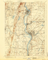
The Connecticut River valley serves as the industrial and transit spine of this late nineteenth-century landscape, anchoring the major urban centers of Springfield, Holyoke, and Chicopee. The mapping details a complex network of power and production, where the Chicopee River and various brooks supported early manufacturing hubs like Chicopee Falls and Indian Orchard. Rail infrastructure is densely represented, including the Boston & Albany R. R. and the Holyoke Branch, which weave through the terrain to connect these river cities.
Find a feature on this map
96 named features on this map. Tap any name to fly to it.
Don’t see what you’re looking for? This feature index may not catch every label — zoom into the map to look around manually.
Map Details
Editions of this 1889 Springfield Map
This is the sole edition of this map. No revisions or reprints were ever made.
Historical Maps of Springfield Through Time
5 maps found