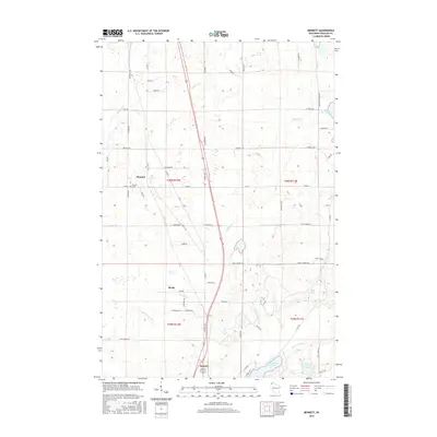
2015 Map of Bennett
USGS Topo · Published 2015About this map
Bennett serves as a central point in this northern Wisconsin landscape, situated along the corridor of Highway 53. The settlement pattern is defined by rural roads often named for early local families, including Karras Rd, Samuelson Rd, and Jackson Rd, which link the small communities of Beebe and Sauntry. The terrain is significantly influenced by glacial hydrology, featuring the expansive Merriam Swamp and a network of water bodies such as Middle River, Poplar River, and Wilson Cr. To the southeast, the geography transitions toward the headwaters of the St. Croix system at Upper Saint Croix Lake and Lake of the Woods. This 2015 survey provides a clear view of the modern infrastructure and historic cemetery locations like Bennett Cem that anchor these Douglas County townships.
Find a feature on this map
71 named features on this map. Tap any name to fly to it.
Don’t see what you’re looking for? This feature index may not catch every label — zoom into the map to look around manually.
Map Details
Editions of this 2015 Bennett Map
This is the sole edition of this map. No revisions or reprints were ever made.
Other maps of this area

1945 · Highland
USGS Topo · 1:48,000

1945 · Solon Springs
USGS Topo · 1:48,000

1947 · Brule
USGS Topo · 1:48,000

1949 · Solon Springs
USGS Topo · 1:48,000

1949 · Poplar
USGS Topo · 1:48,000

1949 · Highland
USGS Topo · 1:48,000

1953 · Ashland
USGS Topo · 1:250,000

1954 · Lake Nebagamon
USGS Topo · 1:24,000
1954 · South Range
USGS Topo · 1:24,000
1954 · Lyman Lake
USGS Topo · 1:24,000