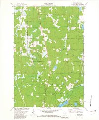
1981 Map of Bennett
USGS Topo · Published 1982About this map
Bennett and Beebe serve as the primary focal points of this northern Wisconsin landscape, situated along the corridor of the Chicago and North Western railroad. The terrain is characterized by a dense network of water and wetlands, notably the expansive Merriam Swamp and the headwaters of several significant streams, including the Middle River and the West Fork Bois Brule River. Local genealogy is well-supported by the presence of three distinct burial grounds—Parkview Cem, Hawthorne Cem, and Bennett Cem—located near the settled areas. Religious life is marked by the Whispering Pines Ch in the northern reach of the survey. The geography transition from the managed timber of the State Forest to the numerous glacial lakes like Lake Minnesuing and Upper St Croix Lake illustrates the region's historical reliance on both natural resources and seasonal recreation.
Find a feature on this map
50 named features on this map. Tap any name to fly to it.
Don’t see what you’re looking for? This feature index may not catch every label — zoom into the map to look around manually.
Map Details
Editions of this 1981 Bennett Map
This is the sole edition of this map. No revisions or reprints were ever made.
Other maps of this area

1945 · Highland
USGS Topo · 1:48,000

1945 · Solon Springs
USGS Topo · 1:48,000

1947 · Brule
USGS Topo · 1:48,000

1949 · Solon Springs
USGS Topo · 1:48,000

1949 · Poplar
USGS Topo · 1:48,000

1949 · Highland
USGS Topo · 1:48,000

1953 · Ashland
USGS Topo · 1:250,000

1954 · Lake Nebagamon
USGS Topo · 1:24,000
1954 · South Range
USGS Topo · 1:24,000
1954 · Lyman Lake
USGS Topo · 1:24,000