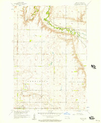
1956 Map of Berlin
USGS Topo · Published 1957About this map
The Northern Pacific railroad cuts through the northern reaches of LaMoure County, following the winding course of the James River as it snakes across the prairie. This mid-century landscape is defined by its townships, including Roscoe, Grandview, Henrietta, and Grand Rapids, each subdivided into a grid of section lines and unimproved roads. At the southern edge of the survey, the small settlement of Berlin sits along the rail line, serving as a local hub for the surrounding agricultural community.
Find a feature on this map
11 named features on this map. Tap any name to fly to it.
Don’t see what you’re looking for? This feature index may not catch every label — zoom into the map to look around manually.
Map Details
Editions of this 1956 Berlin Map
This is the sole edition of this map. No revisions or reprints were ever made.
Other maps of this area

1894 · La Moure
USGS Topo · 1:62,500

1895 · Lamoure
USGS Topo · 1:125,000

1896 · Jamestown
USGS Topo · 1:125,000

1896 · Edgeley
USGS Topo · 1:125,000

1897 · Eckelson
USGS Topo · 1:125,000

1918 · La Moure
USGS Topo · 1:125,000

1925 · Edgeley
USGS Topo · 1:125,000

1952 · Dickey
USGS Topo · 1:24,000

1952 · Grand Rapids
USGS Topo · 1:24,000

1953 · Jamestown
USGS Topo · 1:250,000