1888 Map of Berlin
USGS Topo · Published 1963About this map
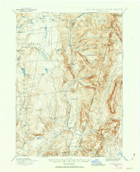
Lebanon Springs Railroad tracks follow the valley floor of Kinderhook Creek, anchoring a string of agricultural and industrial hamlets in late 19th-century New York and Massachusetts. The settlements of Stephentown, Berlin, and South Berlin are situated along this critical transport corridor, while smaller communities like Garfield and Wyomanock sit at the crossroads of the surrounding uplands. The terrain is defined by deep notches and gaps, most notably Petersburg Pass and Berlin Pass, which provided essential transit points through the high ridges of the Taconic range.
Find a feature on this map
72 named features on this map. Tap any name to fly to it.
Don’t see what you’re looking for? This feature index may not catch every label — zoom into the map to look around manually.
Map Details
Editions of this 1888 Berlin Map
2 editions found
Other maps of this area

1886 · Greylock
USGS Topo · 1:62,500

1886 · Becket
USGS Topo · 1:62,500

1888 · Becket
USGS Topo · 1:62,500

1888 · Berlin
USGS Topo · 1:62,500

1888 · Pittsfield
USGS Topo · 1:62,500

1890 · Pittsfield
USGS Topo · 1:62,500

1890 · Berlin
USGS Topo · 1:62,500

1891 · Greylock
USGS Topo · 1:62,500

1893 · Cohoes
USGS Topo · 1:62,500

1893 · Troy
USGS Topo · 1:62,500