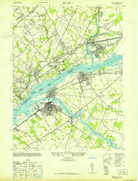
1947 Map of Beverly
USGS Topo · Published 1947About this map
The Delaware River serves as a massive industrial and transit artery in 1947, dividing the burgeoning suburbs of Bensalem, Pennsylvania, from the riverfront towns of Burlington County, New Jersey. The landscape is defined by the heavy infrastructure of the Pennsylvania RR (New York Division) and the Lincoln Highway, supporting a mix of residential growth and institutional facilities. Notable social and healthcare landmarks are concentrated on both banks, including the Philadelphia State Hospital and the Philadelphia Co Prison Farm in the northwest, and the Pa Home for Blind Aged & Deaf near the water. On the New Jersey side, the dense grid of Beverly and Riverside contrasts with the winding course of the Rancocas Creek and the tidal wetlands near Mud Island, illustrating a period when river-dependent industry was beginning to integrate with modern commuter corridors.
Find a feature on this map
72 named features on this map. Tap any name to fly to it.
Don’t see what you’re looking for? This feature index may not catch every label — zoom into the map to look around manually.
Map Details
Editions of this 1947 Beverly Map
This is the sole edition of this map. No revisions or reprints were ever made.
Other maps of this area

1888 · Mount Holly
USGS Topo · 1:62,500

1890 · Burlington
USGS Topo · 1:62,500

1891 · Philadelphia
USGS Topo · 1:62,500

1893 · Germantown
USGS Topo · 1:62,500

1893 · Burlington
USGS Topo · 1:62,500

1894 · Mount Holly
USGS Topo · 1:62,500

1894 · Philadelphia
USGS Topo · 1:62,500

1894 · Germantown
USGS Topo · 1:62,500

1896 · Germantown
USGS Topo · 1:62,500

1896 · Philadelphia
USGS Topo · 1:62,500
Featured Places
- Philadelphia, PA
- Bensalem Township, PA
- Mount Laurel Township, NJ
- Willingboro Township, NJ
- Moorestown Township, NJ