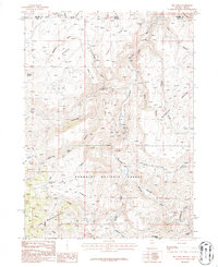
1986 Map of Big Table
USGS Topo · Published 1987About this map
The Bruneau River carves a deep path through this high-elevation landscape on the border of Nevada and Idaho, anchoring a region defined by expansive plateaus and remote outposts. The settlement of Rowland and the nearby Rock House represent the sparse human footprint in this portion of the Humboldt National Forest during the late twentieth century. Land use is largely centered on resource extraction and livestock management, evidenced by the Bruneau Mine and a network of named springs such as Last Chance Spring and Mustang Spring. Distinctive geological features like The Big Table and Mahogany Butte dominate the topography, while the Diamond Desert stretches across the eastern reaches. The presence of a Gaging Station and several remote trails suggest the importance of water monitoring and backcountry access in this arid environment.
Find a feature on this map
38 named features on this map. Tap any name to fly to it.
Don’t see what you’re looking for? This feature index may not catch every label — zoom into the map to look around manually.
Map Details
Editions of this 1986 Big Table Map
This is the sole edition of this map. No revisions or reprints were ever made.
Other maps of this area

1936 · Mountain City
USGS Topo · 1:62,500

1936 · Rowland
USGS Topo · 1:48,000

1940 · Rowland
USGS Topo · 1:62,500

1940 · Mountain City
USGS Topo · 1:62,500

1955 · Twin Falls
USGS Topo · 1:250,000

1955 · Wells
USGS Topo · 1:250,000

1958 · Wells
USGS Topo · 1:250,000

1958 · Twin Falls
USGS Topo · 1:250,000

1961 · Wells
USGS Topo · 1:250,000

1979 · Cowan Reservoir
USGS Topo · 1:24,000