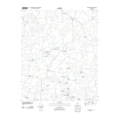
2011 Map of Birmingham
USGS Topo · Published 2011About this map
The settlement of Birmingham and the surrounding rural communities of northern Georgia are captured here in a period of transition toward residential development. This landscape in the city of Milton is defined by its complex network of waterways, where the Little River is fed by numerous tributaries including Canton Creek, Mill Creek, and Chicken Creek. The map reveals an area where traditional landmarks like the Smith Cemetery, Stevens Cemetery, and Phillips Cemetery sit alongside modern recreational footprints such as the Atlanta National Golf Course. Numerous private water bodies and dams, including Statham Lake and Almond Lake, punctuate the terrain, reflecting the modification of the watershed for local land use. Established crossroads like Free Home, Lathemtown, and Holbrook maintain their identities amidst emerging neighborhoods such as Henderson Heights and Tullamore.
Find a feature on this map
136 named features on this map. Tap any name to fly to it.
Don’t see what you’re looking for? This feature index may not catch every label — zoom into the map to look around manually.
Map Details
Editions of this 2011 Birmingham Map
This is the sole edition of this map. No revisions or reprints were ever made.
Other maps of this area

1890 · Suwanee
USGS Topo · 1:125,000

1894 · Suwanee
USGS Topo · 1:125,000

1926 · Tate
USGS Topo · 1:62,500

1928 · Tate
USGS Topo · 1:62,500

1955 · Rome
USGS Topo · 1:250,000

1956 · Duluth
USGS Topo · 1:24,000
1956 · Mountain Park
USGS Topo · 1:24,000

1956 · Roswell
USGS Topo · 1:24,000

1956 · Birmingham
USGS Topo · 1:24,000

1958 · Rome
USGS Topo · 1:250,000