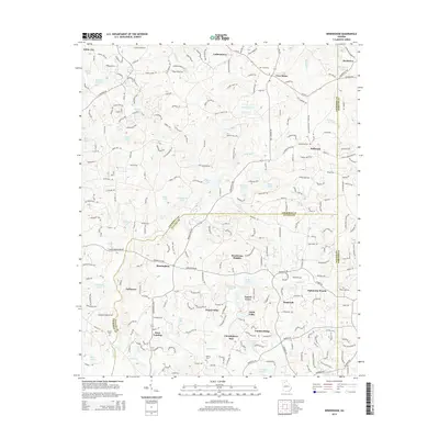
2014 Map of Birmingham
USGS Topo · Published 2014About this map
Birmingham and Holbrook serve as central points for this rural and suburbanizing landscape north of the Atlanta metro area. The map illustrates a transition between established agricultural settlements like Lathemtown and Free Home and newer residential developments such as North Valley, Henderson Heights, and Country Ridge. The northern reaches are defined by a network of waterways including Smithwick Cr and Cotton Creek, while the presence of family burial sites like Smith Cem and Phillips Cem offers critical markers for genealogical research. The region's transport network is anchored by Ga-372 and Ga-20, which facilitate movement between the county lines of Cherokee, Forsyth, and Fulton. A high density of private lakes, such as Statham Lake and Michael Lake, indicates the conversion of the historical watershed into recreational and residential land use.
Find a feature on this map
254 named features on this map. Tap any name to fly to it.
Don’t see what you’re looking for? This feature index may not catch every label — zoom into the map to look around manually.
Map Details
Editions of this 2014 Birmingham Map
This is the sole edition of this map. No revisions or reprints were ever made.
Other maps of this area

1890 · Suwanee
USGS Topo · 1:125,000

1894 · Suwanee
USGS Topo · 1:125,000

1926 · Tate
USGS Topo · 1:62,500

1928 · Tate
USGS Topo · 1:62,500

1955 · Rome
USGS Topo · 1:250,000

1956 · Duluth
USGS Topo · 1:24,000
1956 · Mountain Park
USGS Topo · 1:24,000

1956 · Roswell
USGS Topo · 1:24,000

1956 · Birmingham
USGS Topo · 1:24,000

1958 · Rome
USGS Topo · 1:250,000