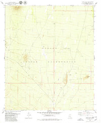
1979 Map of Black Hills
USGS Topo · Published 1979About this map
The Papago Indian Reservation defines this arid landscape in Pima County, where intermittent drainage patterns and low-lying desert peaks dominate the topography. The map detail centers on the Anegan Wash, a primary conduit for seasonal water through the basin, flanked by the Black Hills to the southeast and the Vaca Hills along the northern boundary. Land use in the late 1970s is indicated by a solitary Corral and the wide expanse of Coyote Field, suggesting seasonal ranching activities within the reservation.
Find a feature on this map
13 named features on this map. Tap any name to fly to it.
Don’t see what you’re looking for? This feature index may not catch every label — zoom into the map to look around manually.
Map Details
Editions of this 1979 Black Hills Map
This is the sole edition of this map. No revisions or reprints were ever made.
Other maps of this area

1934 · Silver Bell
USGS Topo · 1:125,000

1937 · Comobabi
USGS Topo · 1:48,000

1938 · San Vicente
USGS Topo · 1:62,500

1941 · San Vicente
USGS Topo · 1:62,500

1942 · San Vicente
USGS Topo · 1:62,500

1942 · Comobabi
USGS Topo · 1:62,500

1948 · San Vicente
USGS Topo · 1:62,500

1956 · Tucson
USGS Topo · 1:250,000

1958 · Tucson
USGS Topo · 1:250,000

1959 · Tucson
USGS Topo · 1:250,000