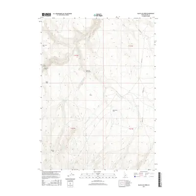
2017 Map of Black Leg Creek
USGS Topo · Published 2017About this map
Black Leg Creek and its tributary Cottonwood Cr carve through this high-elevation corner of Owyhee County, defining a landscape of intermittent drainages and critical water sources. The map reveals the ranching and livestock infrastructure essential to the region, centered on the Black Leg Reservoir and Billings Reservoir. These man-made features, alongside natural points like Rizzi Spring and Willow Spring, represent the vital water network of the J-P Desert plateau.
Find a feature on this map
26 named features on this map. Tap any name to fly to it.
Don’t see what you’re looking for? This feature index may not catch every label — zoom into the map to look around manually.
Map Details
Editions of this 2017 Black Leg Creek Map
This is the sole edition of this map. No revisions or reprints were ever made.
Other maps of this area

1936 · Mountain City
USGS Topo · 1:62,500

1936 · Rowland
USGS Topo · 1:48,000

1940 · Rowland
USGS Topo · 1:62,500

1940 · Mountain City
USGS Topo · 1:62,500

1955 · Twin Falls
USGS Topo · 1:250,000

1955 · Wells
USGS Topo · 1:250,000

1958 · Wells
USGS Topo · 1:250,000

1958 · Twin Falls
USGS Topo · 1:250,000

1961 · Wells
USGS Topo · 1:250,000
1979 · Antelope Creek
USGS Topo · 1:24,000