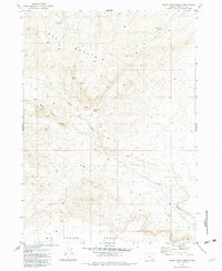
1981 Map of Black Rock Spring
USGS Topo · Published 1982About this map
Lone Mountain dominates this high-desert landscape in Harney County, serving as a prominent landmark in an area defined by its scarce but vital water sources. The 1981 data records a network of isolated springs and livestock management features, such as Winnemucca Spring, Black Rock Spring, and Buck Spring. The presence of a Corral and several locations marked Guzzler—artificial water collectors for wildlife or range stock—indicates the area's primary use for grazing and conservation during the late twentieth century.
Find a feature on this map
10 named features on this map. Tap any name to fly to it.
Don’t see what you’re looking for? This feature index may not catch every label — zoom into the map to look around manually.
Map Details
Editions of this 1981 Black Rock Spring Map
This is the sole edition of this map. No revisions or reprints were ever made.
Other maps of this area

1886 · Disaster
USGS Topo · 1:250,000

1889 · Long Valley
USGS Topo · 1:250,000

1893 · Disaster
USGS Topo · 1:250,000

1954 · Vya
USGS Topo · 1:250,000

1955 · Adel
USGS Topo · 1:250,000

1957 · Adel
USGS Topo · 1:250,000

1958 · Vya
USGS Topo · 1:250,000

1958 · Adel
USGS Topo · 1:250,000

1962 · Vya
USGS Topo · 1:250,000

1962 · Adel
USGS Topo · 1:250,000