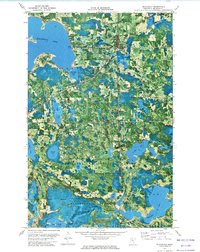
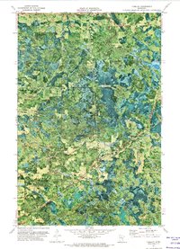
1972 Map of Blackduck
USGS Topo · Published 1974About this map
Blackduck and the surrounding northern Minnesota wetlands are captured here at a time when the region was defined by its vast lakes and the working forestry landscape of the Chippewa National Forest. The map shows a transition from the structured town site of Blackduck, with its Substation and nearby Lakeview Cem, to the intricate water systems of the Blackduck State Forest and Hines townships. The Burlington Northern railroad serves as the primary industrial artery, cutting diagonally through Coburn and past Pine Tree State Park. Notable for local history is the location of Camp Rabideau near the shores of Benjamin Lake and Little Rabideau Lake. This orthophotomap combines aerial photography with traditional topographic contours, offering a unique look at the shoreline configurations of Blackduck Lake and the scattered clearings of the Summit area during the early 1970s.
Find a feature on this map
44 named features on this map. Tap any name to fly to it.
Don’t see what you’re looking for? This feature index may not catch every label — zoom into the map to look around manually.
Map Details
Editions of this 1972 Blackduck Map
This is the sole edition of this map. No revisions or reprints were ever made.
Other maps of this area
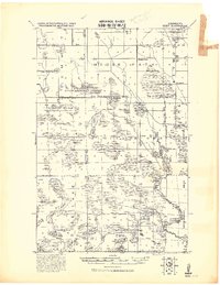
1919 · Rosy
USGS Topo · 1:62,500

1919 · Quiring
USGS Topo · 1:62,500

1919 · Bridgie
USGS Topo · 1:62,500

1924 · Bridgie
USGS Topo · 1:62,500

1954 · Bemidji
USGS Topo · 1:250,000

1957 · Bemidji
USGS Topo · 1:250,000

1958 · Bemidji
USGS Topo · 1:250,000

1971 · Gimmer Lake
USGS Topo · 1:24,000
1971 · Funkley
USGS Topo · 1:24,000

1971 · Decker Lake
USGS Topo · 1:24,000