2022 Map of Blairs
USGS Topo · Published 2022About this map
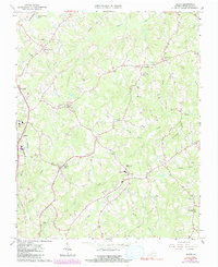
Keeling and the outskirts of Danville define the rural character of this Pittsylvania County landscape. The area is marked by a complex network of waterways, including the winding Sandy Creek in the north and the confluence of Lawless Creek and Birch Creek further south. Local genealogy and history are anchored by the Blankenship Lea Cemetery, situated near the headwaters of Cane Creek. The map documents a blend of established settlements like Kentuck and newer developments such as Beaver Park. Recreational landmarks like Owens Fishing Lakes and the KOA Camp Lake punctuate the drainage basins, while the descriptive Gentlemans Ridge Road traces the high ground between the various forks and branches of the Fall Creek system.
Find a feature on this map
86 named features on this map. Tap any name to fly to it.
Don’t see what you’re looking for? This feature index may not catch every label — zoom into the map to look around manually.
Map Details
Editions of this 2022 Blairs Map
This is the sole edition of this map. No revisions or reprints were ever made.