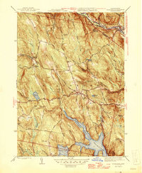
1946 Map of Blandford
USGS Topo · Published 1946About this map
The Cobble Mountain Reservoir and Borden Brook Reservoir dominate the southern landscape of this 1940s survey, illustrating the managed water systems of the Berkshires. The topography is defined by significant elevations like Great Moose Hill and Sunapee Hill, while the Westfield River cuts through the northern corner. Transportation history is deeply etched into the terrain, showing the Boston and Albany RR following the river and the path of the General Knox Turnpike traversing the hills. Historical markers for genealogists include the North Blandford Cem and the St Thomas Cem, alongside smaller settlements like North Blandford and Woronoco Heights. The map reveals a transition between old stage routes and early twentieth-century infrastructure, centered on the town of Blandford.
Find a feature on this map
58 named features on this map. Tap any name to fly to it.
Don’t see what you’re looking for? This feature index may not catch every label — zoom into the map to look around manually.
Map Details
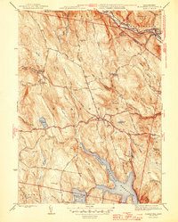
Editions of this 1946 Blandford Map
2 editions found
Other maps of this area

1886 · Chesterfield
USGS Topo · 1:62,500

1886 · Becket
USGS Topo · 1:62,500

1887 · Granville
USGS Topo · 1:62,500

1888 · Becket
USGS Topo · 1:62,500

1888 · Sandisfield
USGS Topo · 1:62,500

1888 · Chesterfield
USGS Topo · 1:62,500

1889 · Granville
USGS Topo · 1:62,500

1893 · Granville
USGS Topo · 1:62,500

1893 · Chesterfield
USGS Topo · 1:62,500

1893 · Becket
USGS Topo · 1:62,500