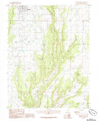
1985 Map of Blanding South
USGS Topo · Published 1985About this map
The town of Blanding sits at the northern edge of a landscape characterized by deep canyon incisions and expansive plateau systems in the mid-1980s. The topography is dominated by the contrasting heights of White Mesa and Mustang Mesa, separated by the drainage of Recapture Creek. This provisional survey illustrates a complex network of points and draws, including Murphy Point and Lems Draw, which guided land use and travel long before modern paved routes. The presence of water sources such as Mustang Spring and Richmond Spring highlights the vital, localized resources necessary for life in this arid region of San Juan County. The map captures a moment of transition where traditional terrain-based landmarks like Road Canyon Point and Ute Point remained the primary identifiers for navigating the corridor south of the settlement.
Find a feature on this map
17 named features on this map. Tap any name to fly to it.
Don’t see what you’re looking for? This feature index may not catch every label — zoom into the map to look around manually.
Map Details
Editions of this 1985 Blanding South Map
This is the sole edition of this map. No revisions or reprints were ever made.
Other maps of this area

1886 · Abajo
USGS Topo · 1:250,000

1892 · Abajo
USGS Topo · 1:250,000

1893 · Abajo
USGS Topo · 1:250,000

1935 · Elk Ridge
USGS Topo · 1:96,000

1940 · Elk Ridge
USGS Topo · 1:125,000

1955 · Verdure 3 SE
USGS Topo · 1:24,000

1955 · Verdure 3 NE
USGS Topo · 1:24,000

1956 · Cortez
USGS Topo · 1:250,000
1957 · Elk Ridge 4 NE
USGS Topo · 1:24,000

1957 · Elk Ridge 4 SE
USGS Topo · 1:24,000