2023 Map of Bliss
USGS Topo · Published 2023About this map
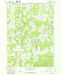
Bliss and its surrounding dairy-country landscape sit at a geographic crossroads where Wyoming, Cattaraugus, and Allegany counties converge. The terrain is defined by the headwaters of several significant drainage systems, including Cattaraugus Creek flowing west and the North Branch Wiscoy Creek feeding into the Genesee River basin. Small rural settlements like Eagle and East Arcade anchor the township, connected by a network of local roads such as Telegraph Rd and Cadwell Rd. For those tracing local history, several established burial grounds like Saint Mary's Cem and Eagle Village Cem are clearly marked. The presence of Keysa Airport north of East Arcade and the recreational waters of Lake Willene illustrate the modern utility of these high-elevation plateaus.
Find a feature on this map
63 named features on this map. Tap any name to fly to it.
Don’t see what you’re looking for? This feature index may not catch every label — zoom into the map to look around manually.
Map Details
Editions of this 2023 Bliss Map
This is the sole edition of this map. No revisions or reprints were ever made.