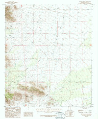
1987 Map of Blue Mountain
USGS Topo · Published 1987About this map
Blue Mountain dominates this portion of the Coronado National Forest in Cochise County, rising above a network of canyons and seasonal drainages. The landscape is defined by its mining history and geological landmarks, with several prospects and the Apex Mine located on the southern slopes near The Nippers and Split Rock. Drainage patterns are clearly visible, showing how East Whitetail Creek and Keating Creek carve through the terrain. These watercourses, along with South Fork Oak Creek and various canyons like Triangle Canyon, illustrate the complex hydrology of this high-elevation desert region during the late twentieth century. The distribution of mining sites near summits like Haystack suggests a legacy of mineral exploration that persists alongside the protected forest lands.
Find a feature on this map
16 named features on this map. Tap any name to fly to it.
Don’t see what you’re looking for? This feature index may not catch every label — zoom into the map to look around manually.
Map Details
Editions of this 1987 Blue Mountain Map
This is the sole edition of this map. No revisions or reprints were ever made.
Other maps of this area

1917 · San Simon
USGS Topo · 1:125,000

1917 · Chiricahua
USGS Topo · 1:125,000

1919 · Chiricahua
USGS Topo · 1:125,000

1926 · Cochise Head
USGS Topo · 1:62,500

1926 · Rodeo
USGS Topo · 1:62,500

1926 · Rucker
USGS Topo · 1:62,500

1928 · Chenoweth
USGS Topo · 1:62,500

1950 · Cochise Head
USGS Topo · 1:62,500

1950 · Vanar
USGS Topo · 1:62,500

1951 · Vanar
USGS Topo · 1:62,500