1913 Map of Bluefield
USGS Topo · Published 1913About this map
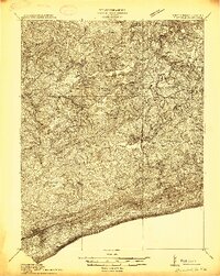
Princeton serves as the focal point of this 1913 survey, situated north of the prominent East River Mountain ridge. The landscape of Mercer Co is defined by a dense network of early 20th-century rural infrastructure, particularly a high concentration of local schools such as Grecian Bend School, Sand Gap School, and Mactor School that served isolated hollows. Along the Bluestone River and its tributaries like Brush Creek and Widmouth Creek, small settlements including Matoaka, Springton, and Hiawatha demonstrate the era's reliance on river valleys for transport and community placement. The map captures the region before the extensive modern developments in South Bluefield, providing a clear view of the mountain gaps and river crossings that dictated the growth of towns like Athens and Spanishburg during the pre-war period.
Find a feature on this map
59 named features on this map. Tap any name to fly to it.
Don’t see what you’re looking for? This feature index may not catch every label — zoom into the map to look around manually.
Map Details
Editions of this 1913 Bluefield Map
This is the sole edition of this map. No revisions or reprints were ever made.
Other maps of this area

1887 · Pocahontas
USGS Topo · 1:125,000

1887 · Hinton
USGS Topo · 1:125,000

1890 · Dublin
USGS Topo · 1:125,000

1891 · Pocahontas
USGS Topo · 1:125,000

1891 · Dublin
USGS Topo · 1:125,000

1891 · Raleigh
USGS Topo · 1:125,000

1892 · Hinton
USGS Topo · 1:125,000

1894 · Pocahontas
USGS Topo · 1:125,000

1895 · Pocahontas
USGS Topo · 1:125,000

1897 · Raleigh
USGS Topo · 1:125,000