1887 Map of Hinton
USGS Topo · Published 1887About this map
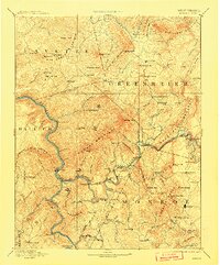
The Greenbrier River carves a winding path through the heart of the Alleghenies in the late nineteenth century, serving as a vital corridor for both transit and trade. The Chesapeake and Ohio Railroad follows the river's tight bends, necessitating major engineering feats like the Big Bend Tunnel and Howards Creek Tunnel to navigate the ridge-heavy terrain. This survey captures a landscape transitioning into an industrial rail hub, anchored by Hinton and the Greenbrier Stock Yards.
Find a feature on this map
131 named features on this map. Tap any name to fly to it.
Don’t see what you’re looking for? This feature index may not catch every label — zoom into the map to look around manually.
Map Details
Editions of this 1887 Hinton Map
This is the sole edition of this map. No revisions or reprints were ever made.
Historical Maps of Hinton Through Time
5 maps found