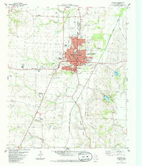
1984 Map of Bonham
USGS Topo · Published 1985About this map
Bonham serves as the focal point of this mid-1980s survey, showing a landscape defined by its transition from an urban center to the surrounding Fannin County prairie. The town's social and historical fabric is documented through several significant sites, including the Sam Rayburn Mem Veterans Center and the Inglish Cem. Beyond the city limits, the Missouri Pacific line cuts across the terrain, passing landmarks like the Midway Drive-in Theater. To the south, the topography rises toward Arledge Ridge and the winding course of Bois d'Arc Creek. Rural life is anchored by small communities like Edhube and Nunnelee, while the Bonham State Park and City Lake offer insights into the region's water management and recreation. Family researchers will find value in the distribution of several local burial grounds, including the Willow Wild Cemetery and Gates Hill Cem.
Find a feature on this map
41 named features on this map. Tap any name to fly to it.
Don’t see what you’re looking for? This feature index may not catch every label — zoom into the map to look around manually.
Map Details
Editions of this 1984 Bonham Map
This is the sole edition of this map. No revisions or reprints were ever made.
Other maps of this area

1954 · Sherman
USGS Topo · 1:250,000

1958 · Bonham
USGS Topo · 1:62,500

1958 · Whitesright
USGS Topo · 1:62,500

1958 · Sherman
USGS Topo · 1:250,000

1964 · Trenton
USGS Topo · 1:24,000
1964 · Gober
USGS Topo · 1:24,000
1964 · Leonard
USGS Topo · 1:24,000
1984 · Lamasco
USGS Topo · 1:24,000
1984 · Dodd City
USGS Topo · 1:24,000
1984 · Lake Bonham
USGS Topo · 1:24,000